I learned several lessons about offshore fieldwork and research a long time ago. One, it never goes as planned; and two, as a result, you usually wind up with more questions than answers when you’re done. Finally, THREE, as a result of these first two variables, you’re usually never, truly done with research.
All three factors were in play when we went back to Apalachee Bay during the second week of August. We planned this round of assessment to delineate the full extent of the Econfina Channel site, which we’ve been working on since 2014. Every time we go out to work on this site, we find more of it. After two years out of the water due to COVID, we thought it was time to address that question finally. How big IS this thing?
What is an Econfina Channel site?
The Econfina Channel site is a large submerged area located about 10 feet underwater. It features several rocky outcrops where stone tools were crafted, and a significant midden (essentially a trash dump) composed primarily of oyster shells. This site was submerged no later than 4,500 years ago and is one of only a few documented locations of its kind in marine environments.
This research could provide answers to several important archaeological questions. One of the key inquiries is how well these sites withstand being submerged due to rising sea levels. We also seek to understand the activities people participated in along that coastline before it became submerged.
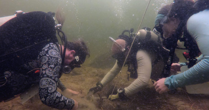
The plan was to relocate the site, fix a buoy on it, and then conduct a visual survey to map the site components comprehensively.
The site was first identified in the late 1980s using LORAN-C this system relies on triangulation instead of a fixed GPS coordinate system. Translation from LORAN-C introduces the potential for error. This will be relevant later. The area is shallow at 15 feet deep, but visibility in the water is limited, usually 20 feet or less.
Typically, we navigate to the coordinates offshore. Then put in a dive team and have them look around to see if they recognize the locale. If not, we offset, using old Coast Guard navigation charts with site maps from all previous surveys. Wash, rinse, and repeat. This, folks, is how we keep finding new site components.
And this process is what led us to find an entirely new site.
We started our visual survey northwest of the coordinates using a different GPS unit than the ones we had used before. After visually identifying the paleochannel from the boat, we tossed some divers off the side, and they came up reporting the typical site components – shell deposits around rocky outcrops. This is exactly what the site looks like. We stuck a buoy on it, took a new set of GPS coordinates on the location (you can never have enough of these!), and went back to the dock.
We felt smug until we discovered something concerning when we entered the new coordinates into the map database back at the field house. It became evident that we were about two-thirds of a mile away from the usual coordinates we rely on. We estimate that a distance conversion error occurred at some point while translating our coordinates into the unit we used to navigate to the site.
Shifting gears offshore
This completely upended the field plan. We had an entirely new site, and it appeared to be BIG. Just like the original one, located on the same submerged river channel, and composed of pretty similar stuff. We had to shift gears to evaluate this new locale and find the old site for real this time, to compare.
It didn’t go as planned, we now have more questions than before, and we are not close to done. To be honest, these are not bad problems to have, but our field schedule is shifting accordingly!
Join us soon for Part III, where we’ll spend some quality time exploring marine taxa, both dead and alive. We’ll also begin to uncover details about what appears to be a significant archaeological landscape offshore in the Gulf of Mexico!
Find us on Facebook
Other FF5 News