FF5 has been quite busy with fieldwork this summer after the long pause we’ve all had to take due to the pandemic. Our focus has been on advancing our research initiatives in Apalachee Bay, Florida, where the peninsula meets the panhandle at the Big Bend of Florida. This summer, we’ve been engaged in fieldwork on Ocholocknee Shoals, south of Wakulla County on the west side of Apalachee Bay.
For our research work, we partnered, as always, with the Aucilla Research Institute (ARI), located in Monticello, Florida, and Georgia-Florida Aerial Search Team (G-FAST), located in Lamont, Florida. ARI is focused on cultural resource research and educational initiatives in the Big Bend. G-FAST provides logistical support for us and ARI; they also provide natural disaster and search-and-rescue support across the entire Gulf region. Both groups are tightly connected to local communities in the region, which is important to us at FF5 as researchers. Our research is meant to benefit our scientific community, but must always, also serve the communities where these sites are located. This is by far the best way to promote shared collaboration and stewardship of these important sites.
Ocholocknee Shoals is a great example of a site where modern community collaboration and stewardship can meet research goals. Ocholocknee Shoals was proposed as a site for renewed survey by Dr. George Cole of ARI several years ago. Dr. Cole is one of the most senior scientific surveyors out there and has spent his entire career advancing the discipline all across Florida and other regions. Dr. Cole has previously done bathymetric LiDAR survey on the eastern side of Apalachee Bay on the paleochannels of the Aucilla and Econfina Rivers, which are both archaeological and geological hot spots, so to speak. The LiDAR data his team obtained mapped both areas to a scale that had never been achieved before. When Dr. Cole discovered that Ocholocknee Shoals, which is today a popular swimming and fishing area in the Bay, had not been mapped since the nineteenth century, his interest was more than piqued. One grant application to the state of Florida later, and the study was on in collaboration with FF5, G-FAST, and ARI.
LiDAR, or Light Detection And Ranging, uses laser scanning to create extremely high-resolution maps of whatever is being scanned. In the case of terrain, it can make maps, usually in the form of Digital Elevation Models (DEMs) with accuracy of around 4 inches. Scanning beneath the surface of the water can be done with specialized lasers designed to cope with light interference in the water column. This type of LiDAR, called bathymetric LiDAR, isn’t quite as accurate as terrestrial LiDAR and it can’t penetrate deeper than about 50 feet. However, Ocholocknee Shoals is very shallow – less than 30 feet deeper in the deeper sections – and it lies in a portion of the Bay that tends to have relatively clear water. It’s a great study area, in other words, for bathymetric LiDAR survey.
Dr. Cole didn’t want to this study to rely solely on the LiDAR scanning, however. To really advance knowledge, studies like this require what we call “ground-truthing”, which is just jargon for “let’s go take an actual look”. For Ocholocknee Shoals, that meant diver survey at various locations across the shoals. By the time the LiDAR survey was done, FF5 had coordinate with Dr. Cole, ARI, G-FAST, and the LiDAR scanning company to develop a plan for this phase of the project. The objectives were threefold. First, we needed to characterize the seabed – is it sandy, is there eel grass present, how deep is it, and how coarse or fine are the sediments? Second, what is the geology of each target area like – are rocky outcrops present, or flowing freshwater springs (common in the Gulf offshore), for example? Third, is there any submerged pre-contact archaeology present at these sites?
To answer these questions, FF5 personnel went offshore along with ARI divers and G-FAST crews to test multiple areas on the shoals in May and June of 2022. Out of two rounds of fieldwork, we managed to get 6 days in the water offshore, which is pretty good for that time of year given the tendency of the Gulf to generate afternoon storms in the Florida summer heat. We assessed about seven different areas across the shoals in depths ranging from 6 to 25 feet and observed multiple different kinds of marine environments.
Shallower portions of the shoals on the eastern side of the area were generally covered in eel grass beds and had fine and very fine sands on the surface of the seabed. We didn’t see any real evidence for rock outcrops or spring outflow points in these areas, either. Marine life was relatively abundant, including one very cool sea turtle siting. We detected one paleochannel feature that runs from north to south along the eastern portion of the shoals. Unlike the paleochannels on the east side of the bay that tend to contain obvious archaeological deposits, however, this channel was very infilled with these same fine to very fine sands and overgrown with eel grass. Any archaeological remains that might have been present alongside this channel are buried now. While this is frustrating to researchers like us who want to find these deposits, it’s good news for archaeological preservation because anything archaeological in this area is protected by having been buried in this way. This is especially good news considering that this part of the shoals is between 6 and around 15 feet deep and could be more easily impacted by modern activities that could potentially damage archaeological deposits.
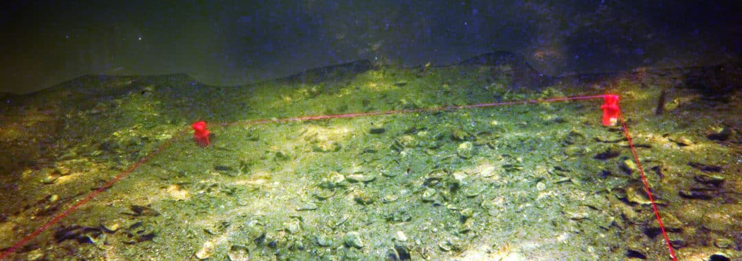
However, we still needed to look at some deeper targets, so we moved to the western side of the shoals and into deeper waters. These new areas were around 20 feet deep, and there was no more eel grass anywhere in the areas we dove. The sand on the seabed was much coarser, as well. It contained a lot of shell hash (broken up pieces of shell) and rocky outcrops dotted the seabed. When we took a closer look at these outcrops, we could detect that they were composed of both St. Marks limestone, which is the typical bedrock for this part of Florida, as well as harder material that sounded an awful lot like chert when tapped with a rock hammer. Why do we care? We care because chert was highly valued by First Americans for crafting very high-quality stone tools. Where you find chert in the Big Bend, you tend to find archaeological deposits. This was very, very good news for us.
We also looked around as much as possible for flowing freshwater springs across these deeper dive sites. Unfortunately, we never did locate an obvious example of a spring vent, but this is not surprising given how little time we had offshore. We were only able to log around six to nine diver hours per day over the six total days offshore, for a total, of most, fifty-four diver hours on targets. Contrast this with a standard eight-hour day on survey with a four-person crew, which comes to thirty-two person hours in the field in just one day! Despite not seeing an actual spring vent, however, we did detect proxy evidence that they were close by at two target locations. Water temperature changes, for example, and the appearance of very fine sediments that appear in areas where water turns brackish (such as where a freshwater spring flows into a marine environment), both suggested that we weren’t far off these targets.
Overall, the field season was a success, by our standards. Underwater survey and prospection present challenges that are significant! We overcame non-optimal topside weather, equipment problems, and limited visibility at depth to delineate at least four different seabed environments at different depths and locations across Ocholocknee Shoals that did not appear in the LiDAR, rounding out that dataset with empirical observations and complementing the mapping efforts spearheaded by Dr. Cole. We also refined our predictive models for where we will be most likely to recover true archaeological deposits in future fieldwork. And we had a good time doing it with our invaluable partners and dear friends from ARI and G-FAST, who in turn help us foster community stewardship of this very special part of the Gulf of Mexico.
Stay tuned for future fieldwork and shenanigans.
JWCH